Picture this: coffee on your terrace as the bay wakes up, a five-minute stroll to St. Armands Circle for breakfast, then a quick walk or bike to Lido Beach. If you want a true island lifestyle with dining, arts, and boating at your door, living on the water near the Circle delivers. You also want clarity on dockage, water depths, flood maps, and permits before you buy. This guide gives you a grounded look at the lifestyle, the waterfront housing mix, and the practical steps that protect your investment. Let’s dive in.
Why St. Armands waterfront works
St. Armands Circle is a compact, walkable district of boutiques, galleries, and restaurants wrapped around a central park. The City’s overview highlights the Circle’s pedestrian feel and proximity to Lido Beach, which defines daily life here for many residents. Explore the area’s layout and offerings on the City’s page for St. Armands Circle.
From your front door, you can reach Lido Beach and South Lido Park by foot or bike for a morning swim, sunset walk, or a quiet mangrove paddle. Visitor resources also outline the retail and dining mix around the Circle; see the St. Armands Circle Association for a taste of the scene.
Connectivity is easy. The free Bay Runner trolley links St. Armands, Lido, and downtown Sarasota, adding flexibility on busy days. The City’s St. Armands page notes these visitor-friendly connections, which support the area’s resort-style convenience.
Housing at the water’s edge
Living near the Circle puts you next to a varied waterfront fabric. You will find canal and bayfront single-family homes, mid-century cottages ready for reinvention, and low- to mid-rise condominiums a short walk or ride from the beach and shops. Each option trades off privacy, maintenance, and dockage in different ways.
Condos with convenience
If you prefer lock-and-leave living, nearby condominiums offer a practical base with managed amenities. Some buildings provide on-site or nearby marina-style options or dry storage access, which simplifies boat ownership. You gain predictable maintenance and community rules in exchange for HOA oversight.
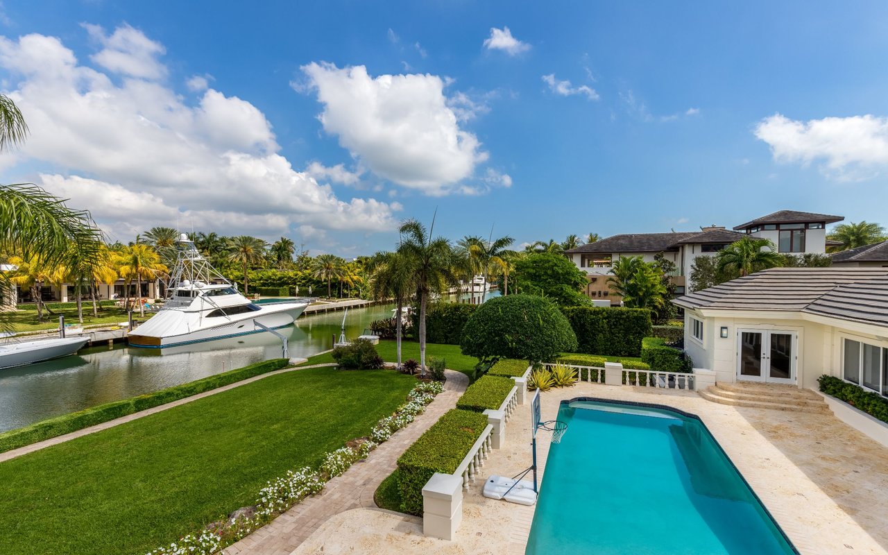
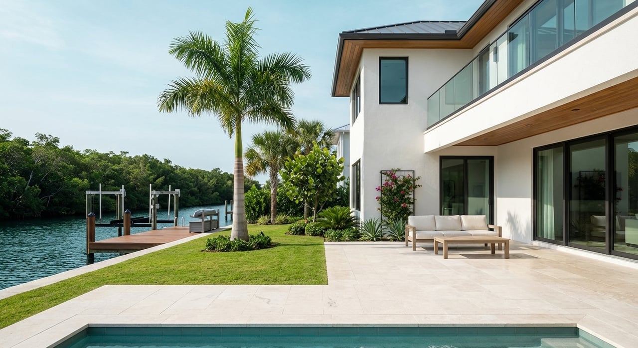
Canal and bayfront homes
Single-family homes on canals or directly on the bay provide private dockage and more control over vessel size and lift capacity. Orientation and lot width matter. Canal frontage usually means calmer water and easier boarding. Bayfront lots offer sweeping views and instant access to open water, with more exposure to wind and wave. Lot width and water depth at your dock will shape what you can safely berth.
Price snapshot
Waterfront property here commands a premium relative to mainland Sarasota. Real estate indices place the area in a multi-million-dollar bracket, but values vary sharply by lot type, frontage, and whether you have direct bay, canal, or Gulf orientation. Treat any number as a moving target and evaluate each property on its merits, including elevation, age, and build quality.
Boating access and dock options
Private dock or marina slip
Many buyers want a private lift steps from the back door. Others prefer full-service marina amenities without the upkeep. Downtown on the bayfront, Marina Jack provides wet slips, fuel, pump-out, and transient dockage for a wide range of vessels. As a nearby public launch, Ken Thompson Park on City Island offers multi-lane ramps, kayak launches, and courtesy docks for quick days on the water.
Routes to the Gulf
From St. Armands and Lido, you typically run Sarasota Bay through marked channels to a pass such as New Pass to reach the Gulf. Depths and shoaling patterns change seasonally, so local operators check recent soundings and notices. Before you close, confirm route depths to the pass for your vessel, and ask local marinas or charter operators for current intel. For practical context on launches and routes around the Suncoast, review regional boating access listings.
Permits and riparian basics
Dock, lift, and seawall work in Florida usually requires city or county permits, and sometimes state and federal authorization when structures extend waterward of the mean high water line or affect navigable waters. The U.S. Army Corps of Engineers explains when federal permits may apply and where to start; see the Jacksonville Regulatory Division’s guidance page. Before you buy, confirm existing permits for docks and shoreline work and understand recorded riparian rights in the deed.
Flood, insurance, and resilience
Flood risk is a core part of waterfront ownership. FEMA’s Flood Insurance Rate Maps for the City of Sarasota were updated and became effective on March 27, 2024. Lenders and insurers rely on these maps, along with your structure’s elevation relative to base flood elevation. The City outlines mapping and floodplain resources on its Flood Map Information page. Your due diligence should include obtaining a FIRMette for the property and a current elevation survey.
For long-range planning, NOAA’s Sea Level Rise Viewer helps you visualize potential tidal flooding scenarios. It is an authoritative tool used by local planners; explore the NOAA Sea Level Rise Viewer. Sarasota County has also completed a Vulnerability Assessment and is developing an Adaptation Plan that looks ahead to 2040 and 2070. These efforts identify assets and projects that could shape shoreline and drainage priorities; learn more on the county’s resiliency planning page.
Daily life highlights
The lifestyle here blends beach time with culture and dining. A typical week might include Lido Beach sunsets, errands and dinners around the Circle, and paddles through South Lido’s mangroves. For arts and culture, many residents frequent the Ringling Museum and downtown bayfront venues. To plan an outing, visit the Ringling Museum.
Buyer checklist for waterfront near the Circle
Use this short list to focus your due diligence before you write an offer:
Conveyancing and surveys
- Confirm deeded riparian rights and any recorded easements. Order a boundary survey that locates the mean high water line and any seawall.
- Request permit history and any as-built drawings for the dock, lift, and seawall. Unpermitted structures can limit upgrades and timing.
Navigation and boat logistics
- Get recent depth soundings at the dock and along the route to the nearest marked channel and pass. Ask local marinas about current shoaling patterns near New Pass. Review regional boat launch resources for practical context.
- Verify bridge clearances if you run a sailboat or a tall tower. When in doubt, consult the permitting authorities or a marine surveyor.
Structural and maintenance items
- Inspect seawall and tiebacks for movement or settlement. Understand expected lifespan and potential replacement costs.
- Evaluate dock piles, decking, and lift capacity. Confirm electrical service and lighting meet code and marine best practices.
Regulatory and insurance
- Check the current FEMA flood zone using the City’s Flood Map Information. Obtain a preliminary flood insurance quote early.
- If you plan dock or seawall work, review local permit requirements and whether state or federal authorization applies. Start with USACE’s regulatory overview.
Quality of life and mobility
- Time the walk and bike to St. Armands Circle and Lido Beach, and test peak-season parking conditions near your block. The City’s St. Armands Circle page outlines local visitor context and trolley connections.
- If you prefer marina amenities over a private dock, confirm slip availability and services at Marina Jack or plan to use Ken Thompson Park as your launch base.
Final thought
Living near St. Armands Circle on the water is about ease. You can walk to dinner, watch the sunset from your dock, and be in the Gulf after a short run through the bay. With the right due diligence on dockage, depths, permits, and flood maps, you can buy confidently and enjoy the lifestyle you came for. If you want a clear, discreet plan for your search, connect with Cassandra Miller for a confidential consultation tailored to your goals.
FAQs
What types of waterfront homes are near St. Armands Circle?
- You will find canal and bayfront single-family homes, mid-century cottages, and low- to mid-rise condos within walking or quick-biking distance of the Circle.
How close are the beach and dining options to homes on St. Armands Key?
- Lido Beach and St. Armands Circle are a short walk or bike ride from nearby residential streets, with the free Bay Runner trolley linking the islands and downtown.
What should you know about boating routes and New Pass?
- Expect to navigate Sarasota Bay via marked channels and monitor seasonal shoaling near passes like New Pass; confirm depths with recent soundings and local operator intel.
Do you need flood insurance in this area?
- Lender requirements depend on the current FEMA flood zone and your structure’s elevation; review the City’s Flood Map Information and obtain a quote early in the process.
Where can you launch or keep a boat if you do not have a private dock?
- Consider a slip at full-service Marina Jack or use Ken Thompson Park for public launching and kayak access.